

Two Moors Way Exmoor section self-guided walk in four walking days with luggage transfer
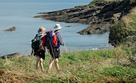
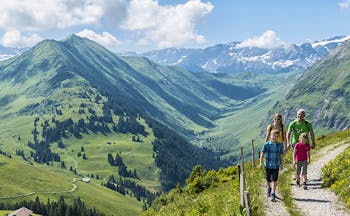
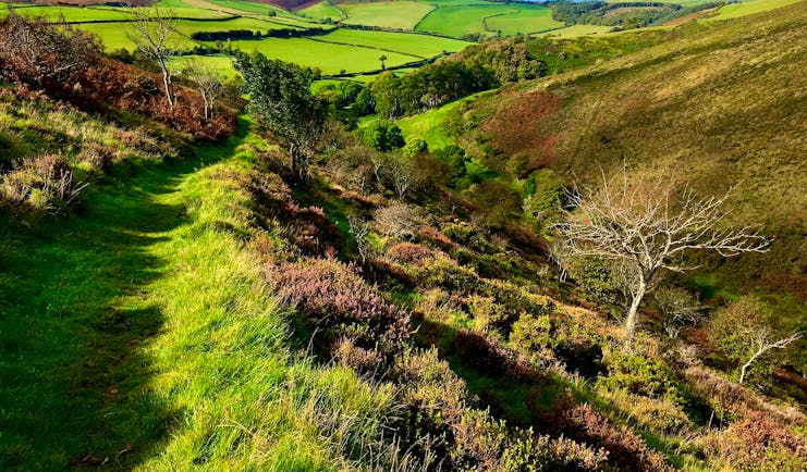
This is an Exmoor version of the classic Two Moors Way self-guided walk with luggage transfer and stays in small hotels, pubs and B&Bs. You experience typical mid-Devon and Exmoor countryside of fields of grazing sheep and cattle, rich red soils of farming land, densely wooded valleys, running streams and rivers tumbling over boulders, mediaeval stone bridges and charming villages. The terrain is varied and includes earthy leafy paths, wide springy moorland tracks, grassy fields, stone paths, and some tarmac stretches of road. The variety also applies to the gradient: some stretches are steep down and up again and others allow for a steady march along a ridge line, where you can pick up speed and relax in the breeze whilst soaking up the vistas. You encounter both well-known and less well-known aspects of the history and culture of this countryside with the mediaeval Tarr Steps, Eliza Wheal copper mine, Cow Castle and Simonsbath 19th Century village. The colours change with the seasons: in spring you’ll see carpets of bluebells and in late summer and autumn swathes of purple heather. You may see the Exmoor ponies and red deer have survived here since pre-historic times. For part of the walk you trace the River Barle, a natural river of very high quality and is home to much flora and fauna including otter, kingfisher, dipper, salmon, mosses and liverworts and three nationally-scarce beetles.
Highlights
Tarr Steps • Exmoor • Exe Head • Combe Park Wood • Myrtleberry Cleave • Lynmouth
Walking information
Average of 10 miles/16 kms per walking day • Average of 5 hours’ walking per day • Moderate • Moorland, wooded valleys, pastureland, fields • Recommended March to end October
Holiday price guide Sample prices are per person based on two people sharing a double or twin room for 6 nights.
From about
£620
Holiday Code CW005
Additional nights can be added before, after or during the tour.
Call us on 01392 441266
Two Moors Way Exmoor section self-guided walk in four walking days with luggage transfer
You reach your first overnight stop in the course of the day. Remember to pre-book a table if you want to dine in. Allow time to check your kit, pack your rucksack and study your guides and maps. Witheridge is situated between Dartmoor and Exmoor and on the route of the Two Moors Way. In the Square is the church and the old coaching inn, the Mitre, dating from the 1830s.
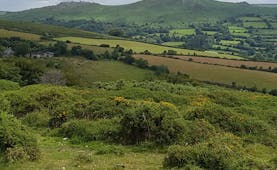
This is a good introductory day as you may want to plan ahead and treat yourself to dinner in the Michelin-starred Masons Arms in Knowstone this evening (closed on Sunday evenings and Mondays at the time of writing). Woodland, water meadow, fields of wildflowers and wildlife such as fallow deer and buzzards can be found today. As you cross the Little Dart you’ll see Bradford Mill which was a working mill from the 17th until the 20th century. There is also moorland at Creacombe where you climb to over 800ft (almost 250m) above sea level and enjoy views over the rolling farmland towards the southern edge of Exmoor. Soon you’ll experience another Devon green lane and then open land surrounded by a network of small fields at Knowstone Moor. There is the Outer Moor and the Inner Moor and along with nearby Hares Down, these patches of land are now rare culm grassland, a mixture of purple moor-grass and wet heath, which absorbs water at five times the rate of ordinary grassland. Locals still have common grazing rights to the land. Knowstone is a pretty cluster of houses and a designated conservation area with a 15th century church and unspoiled churchyard.
Distance: About 8 miles
Time: About 4 hours
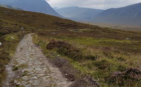
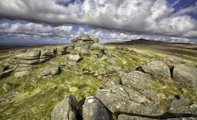
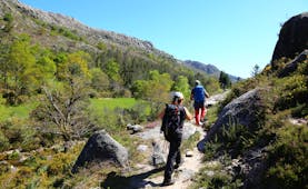
The day starts by a traverse of the mid-Devon rural landscape, down and uphill. On Owlaborough Moor are tumuli, vestiges of the occupation of this land over the centuries and a little further on is the dismantled track of the Devon and Somerset Railway and the tiny village of Yeo Mill, where there are signs in its former coaching inn and village shop that these places would have been busier in times gone by. Enjoy the streams, hedges, green lanes and wooded patches before reaching the village of West Anstey with its 14th century church dedicated to St Petrock. You skirt common land and soon enter the start of the Exmoor section of the Two Moors Way. Note the sign which tells you that there are only 24 miles to go to Lynmouth. You have views to the village of Hawkridge sitting above the valley of Dane’s Brook to the south and the attractive valley of the River Barle to the north. At Hawkridge you meet the Exe Valley Way. The Two Moors then follows the side of the ridge, forested below you as it drops down to the river, before you descend to the iconic Tarr Steps. Tarr Steps is a 17-span clapper bridge located at an ancient fording point of the River Barle and one of the longest of its kind in Britain. The woodlands around the Tarr Steps and along the banks of the River Barle are a National Nature Reserve and are significant for the mosses, liverworts and lichens that are found here. There is also a moss found in burrows which appears to glow in the dark. There are mature hazel, blackberry and honeysuckle and otters feed on the fish and eels found in the river. Dippers and kingfishers are likely to be seen on the river. Just above Tarr Steps is Winsford Hill and its extension, South Hill, home to the Anchor herd of Exmoor ponies, free living and thought to be a race of wild horse rather than a breed. From Tarr Steps the gradients are gentler, but conditions underfoot are often uneven and muddy, as the riverside path to Withypool has suffered flood damage over the years. From Tarr Steps you head along the riverside path which does become uneven over rocks along the edge of the river for a relatively short stretch, although this can be wet. There are also spots which will be muddy in between tree roots. Having said that, it is a magical stretch of the walk, as the sunlight plays through the branches and leaves of the trees and you listen to the water of the river as it tumbles over rocks. After a while there is a charming stretch through riverside meadows before an ascent into woods above Withypool, before you drop down by the road into the village and find the Royal Oak Inn on your right-hand side.
Distance: About 14 miles
Time: About 7 hours
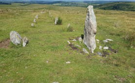
From Withypool you ascend from the village through fields and then follow a quiet lane gently uphill until it reaches moorland. The track crosses the moorland above the wide valley affording wonderful views and from here you can see the historic Landacre Bridge. Exmoor ponies may be seen in this area too. The track across the moor is wide and easy before you drop down slightly to follow the river more closely. Ahead is Cow Castle, an iron age fort, and beautiful wildflower meadows along the riverbank. In high summer there are splashes of orange crocosmia along the route here. It can be boggy and wet underfoot before you reach the higher ground as the path tracks around Cow Castle. There is more beautiful riverbank before you reach the remains of Wheal Eliza, once a copper mine. From here to Simonsbath the path has been restored for all levels and it’s quite wide and relatively flat as you follow it slightly above the river at this point.
Distance: About 6 miles
Time: About 3 hours
Today you use Simonsbath as your base for exploring Exmoor. Simonsbath is an Exmoor village created largely in the 1800s by John Knight who developed the area. Simonsbath House was the original residence of John Knight’s family. There is a sawmill that the National Park restored and is used to cut sessile oak for signs and gates, powered from a leat taking its water from upstream. The River Barle rises nearby at Pinkery Pond. In May and June there is the Simonsbath Festival. There is a local circular walk of about 3.5 miles to Prayway Head or ask the hotel to suggest.
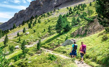
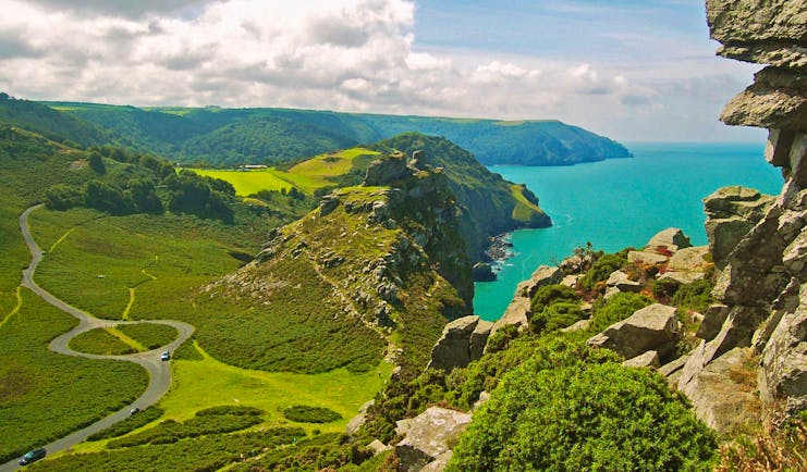
This is the final stage of the Two Moors Way and it’s a fitting end to the route with what can be a demanding day with the ground underfoot being rough and boggy as you climb out of Simonsbath and the valley through the Ashcombe Plantation onto moorland towards the source of the River Exe and the watershed. You cross the Chains, Exmoor’s highest and remotest area, which rise to 1599 ft (487m) and usually displaying white cotton grass in high summer. You follow the side of the valley of Hoaroak Water to reach the Hoar Oak tree which marks the boundary of the Royal Forest and which stands on the Devon-Somerset border. Here you re-entre Devon and then proceed over more high ground at Cheriton Ridge. Views to the east are towards Brendon Common and beyond that Doone Country, which inspired R D Blackmore’s novel Lorna Doone. You enter the woodland of the National Trust’s Coombe Park which incorporates one of the largest areas of semi-natural woodland in the southwest. There are tremendous views over the wooded, steep valley of the East Lyn river and patches of sea to be spied ahead. Following Coombe Park wood is the National Trust’s Watersmeet House, at the confluence of the Hoaroak and East Lyn rivers. You pass the iron age enclosure of Myrtleberry South and then enjoy the spectacular views as the East Lyn runs through Myrtleberry Cleave. There is still some uphill climbing with a zigzag just before, finally, there is a long descent into Lynmouth.
Distance: About 11 miles
Time: About 6 hours
Holiday price guide Sample prices are per person based on two people sharing a double or twin room for 6 nights.
From about
£620
Holiday Code CW005
Additional nights can be added before, after or during the tour.
Our prices include
● Accommodation in a double or twin room on bed and breakfast
● Packed lunch every day except day of arrival
● Luggage transfer between hotels
● Guidebook and our walking notes
Call us on 01392 441266
Holiday price guide Sample prices are per person based on two people sharing a double or twin room for 6 nights.
From about
£620
Holiday Code CW005
Additional nights can be added before, after or during the tour.
Our prices include
• Accommodation in a double or twin room on bed and breakfast
• Packed lunch every day except day of arrival
• Luggage transfer between hotels
• Guidebook and our walking notes
The journey and how you get there
There is a railway station at Morchard Road (about 6.5 miles away) or Exeter St David’s is about 15 miles away. The nearest stations to Lynmouth are at Barnstaple, Tiverton Parkway and Taunton. Barnstaple can be reached by bus from Lynmouth and then there are regular trains to Exeter.
We do not include taxis but can provide contact details for taxi companies. Also, if you need a taxi during the walk (which may be required depending on where you stay), your hotel will be able to arrange it for you. Luggage transfer is included from hotel to hotel for you for up to two items of luggage.
Call us on 01392 441266
Two Moors Way Exmoor section self-guided walk in four walking days with luggage transfer
Village pub with five cosy rooms dating from the 17th Century with open fire and good food.
Double room en-suite
This is a charming B&B with three rooms within walking distance of the famous pub restaurant in the village. Dinner can be provided when restaurant is closed.
Double room
An 18th century pub with quality dining and a wide choice of dishes and very comfortable rooms.
Double room
This hotel is over 350 years old and stands on the river Barle. Combines tradition and comfort. All rooms have valley view. 2 and 3 course options for dinner.
Standard double room
A village inn in the valley of Brendon with rooms and traditional restaurant serving locally sourced seafood, poultry and game as well as Exmoor venison.
Double room
Holiday price guide Sample prices are per person based on two people sharing a double or twin room for 6 nights.
From about
£620
Holiday Code CW005
Additional nights can be added before, after or during the tour.
Our prices include
• Accommodation in a double or twin room on bed and breakfast
• Packed lunch every day except day of arrival
• Luggage transfer between hotels
• Guidebook and our walking notes
The journey and how you get there
There is a railway station at Morchard Road (about 6.5 miles away) or Exeter St David’s is about 15 miles away. The nearest stations to Lynmouth are at Barnstaple, Tiverton Parkway and Taunton. Barnstaple can be reached by bus from Lynmouth and then there are regular trains to Exeter.
We do not include taxis but can provide contact details for taxi companies. Also, if you need a taxi during the walk (which may be required depending on where you stay), your hotel will be able to arrange it for you. Luggage transfer is included from hotel to hotel for you for up to two items of luggage.
Call us on 01392 441266
Two Moors Way Exmoor section self-guided walk in four walking days with luggage transfer
About Great Britain
The countries of Great Britain, England, Scotland and Wales, provide a wealth of beautiful and interesting walking terrain. Within a relatively small area there is a richness of diversity of geography and topography, peoples and dialects, local architecture and traditions and a rich history that has been world-facing and world-interacting for thousands of years. The landscape of this small island varies every few miles, with dales and vales, moors and coastline never far away and here and there you find proud post-industrial cities, flourishing cathedral cities, gentle market towns and picturesque villages, perhaps with a village green, pond, cricket pitch and ancient church, as well as the local pub. Traditions of local heritage feature strongly with festivals and pageants, local arts and crafts and artisan produce. There are many National Parks and designated walking paths. There are recognised coast to coast walks such as the Two Moors Way from the English Channel to the Atlantic Ocean, or the Coast to Coast walk in northern England; there are walks that cover historic landmarks such as Hadrian’s Wall; there are walks that introduce the rambler to the awe-inspiring natural landscape of lakes and mountains such as the West Highland Way; there are walks that hug the dramatic coastline of Great Britain such as the South West Coastal Path or the Northumberland Coast Path. Ordnance Survey maps provide support from not just contours and terrain but historic and noteworthy points of interest too. Within many walks of just a few miles, the rambler will experience a delightful variety of terrain, aspect and vegetation.
Facts in brief
Capital LondonAirport London Heathrow, London Gatwick
Size 209,331 sq km
Population 64.55 million